| Type: | Package |
| Title: | Hydro-Meteorological Catchments Datasets for the 'airGR' Packages |
| Version: | 0.2.3 |
| Date: | 2025-12-04 |
| Description: | Sample of hydro-meteorological datasets extracted from the 'CAMELS-FR' French database <doi:10.57745/WH7FJR>. It provides metadata and catchment-scale aggregated hydro-meteorological time series on a pool of French catchments for use by the 'airGR' packages. |
| License: | CC BY 4.0 |
| Encoding: | UTF-8 |
| Depends: | R (≥ 3.5.0) |
| Suggests: | testthat |
| URL: | https://gitlab.irstea.fr/HYCAR-Hydro/airgrgalaxy/airgrdatasets |
| BugReports: | https://gitlab.irstea.fr/HYCAR-Hydro/airgrgalaxy/airgrdatasets/-/issues |
| NeedsCompilation: | no |
| LazyData: | true |
| Packaged: | 2025-12-04 14:49:52 UTC; odelaigue |
| Author: | Olivier Delaigue  [aut, cre],
Pierre Brigode
[aut],
Guillaume Thirel
[aut],
Benoît Génot [ctb],
Guilherme Mendoza Guimarães
[ctb]
[aut, cre],
Pierre Brigode
[aut],
Guillaume Thirel
[aut],
Benoît Génot [ctb],
Guilherme Mendoza Guimarães
[ctb] |
| Maintainer: | Olivier Delaigue <airGR@inrae.fr> |
| Repository: | CRAN |
| Date/Publication: | 2025-12-04 15:30:02 UTC |
Hydro-Meteorological Catchments Datasets for the 'airGR' Packages
Description
Sample of hydro-meteorological datasets extracted from the 'CAMELS-FR' French database <doi:10.57745/WH7FJR>. It provides metadata and catchment-scale aggregated hydro-meteorological time series on a pool of French catchments for use by the 'airGR' packages. More especially, it can be used by teachers and students for hydrological modeling exercises adapted to the 'airGRteaching' package (doi:10.32614/CRAN.package.airGRteaching), as described in Delaigue et al. (2023) and in the 'airGRteaching' vignettes.
The package contains the following types of datasets:
-
lumped_daily: a collection of daily hydrometeorological time series of lumped catchments, along with associated metadata.
Source
Delaigue, O., Guimarães, G. M., Brigode, P., Génot, B., Perrin, C., and Andréassian, V. (2024). CAMELS-FR dataset, V1, Recherche Data Gouv [data set], doi:10.57745/WH7FJR.
References
Delaigue, O., Brigode, P., Thirel, G., and Coron, L. (2023).
airGRteaching: an open-source tool for teaching hydrological modeling with R,
Hydrol. Earth Syst. Sci., 27, 3293–3327,
doi:10.5194/hess-27-3293-2023.
Delaigue, O., Guimarães, G. M., Brigode, P., Génot, B., Perrin, C., Soubeyroux, J.-M., Janet, B., Addor, N., and Andréassian, V. (2025).
CAMELS-FR dataset: a large-sample hydroclimatic dataset for France to explore hydrological diversity and support model benchmarking,
Earth Syst. Sci. Data, 17, 1461–1479,
doi:10.5194/essd-17-1461-2025.
Metadata and daily time series of catchment-scale hydro-meteorological observations
Description
Meteorological forcing is derived from the SAFRAN reanalysis (8 km resolution grid) produced by Météo-France (Quintana-Seguí et al., 2008; Vidal et al., 2010).
Meteorological forcing is aggregated at the catchment scale and merged with streamflow data within the CAMELS-FR database from INRAE (Delaigue et al., 2024; Delaigue et al., 2025). To accomplish this, catchment boundaries, area, and elevation are determined using two digital terrain models (DTMs). For continental metropolitan France, we used the 100 m × 100 m resolution DTM from the Shuttle Radar Topography Mission (SRTM) project (Rabus et al., 2003; Farr et al., 2007), while for Corsica, the BD ALTI v1.0 with 25 m × 25 m resolution from IGN (2001) was employed. Stations were snapped to a theoretical river network derived from the DTMs, with flow directions constrained using the stream-burning method and the CARTHAGE river network (French water agencies, 2017) after channel removal.
The streamflow data, as well as the codes and names of hydrometric stations, are provided by SCHAPI (the French Central Hydrometeorological and Flood Forecasting Support Service) via the Hydroportail website (SCHAPI, 2022). Streamflows are converted to mm/d using the DEM-based catchment area
Usage
A273011002
A605102001
B222001001
E540031001
E645651001
H010002001
H120101001
F439000101
H622101001
J171171001
J421191001
K134181001
K265401001
K731261001
V123521001
X031001001
X045401001
Y643401001
Y862000101
Format
[list] of 3 elements:
Meta [list] metadata
-
Code[list] of 2 [character] codes of the hydrometric station (H3: code since 2022,H2: former code) -
Name[character] name of the hydrometric station (H3) -
Coor[list] of 2 [numeric] coordinates (XandY) of the catchment outlet [decimal degrees; epsg: 4326] -
Area[numeric] area of the catchment [km²]
TS [data.frame] catchment daily time series from 1999-01-01 to 2018-12-31
-
Date[POSIXct] dates (timezone = "UTC") -
Ptot[numeric] total precipitation (liquid + solid) [mm/d] -
Temp[numeric] mean air temperature [°C] -
Evap[numeric] total potential evapotranspiration computed with Oudin's Formula (Oudin et al., 2005) -
Qls[numeric] outlet streamflow [l/s] -
Qmmd[numeric] outlet streamflow [mm/d]
Hypso [numeric] hypsometric values (101 quantiles from 0 to 100 % of the elevation range of the catchment) [m]
Note
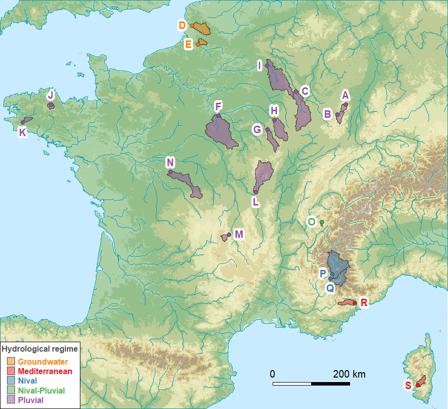
List of available catchments:
station_code | id_map | station_name |
A273011002 | A | the Bruche at Russ [Wisches] |
A605102001 | B | the Meurthe at Saint-Dié-des-Vosges |
B222001001 | C | the Meuse at Saint-Mihiel |
E540031001 | D | the Canche at Brimeux |
E645651001 | E | the Nièvre at Étoile |
F439000101 | F | the Loing at Épisy |
H010002001 | G | the Seine at Plaines-Saint-Lange |
H120101001 | H | the Aube at Bar-sur-Aube |
H622101001 | I | the Aisne at Givry |
J171171001 | J | the Trieux at Saint-Péver - Pont Locminé |
J421191001 | K | the Odet at Ergué-Gabéric - Treodet |
K134181001 | L | the Arroux at Rigny-sur-Arroux |
K265401001 | M | the Couze Pavin at Saint-Floret |
K731261001 | N | the Indre at Saint-Cyran-du-Jambot |
V123521001 | O | the Ire at Doussard |
X031001001 | P | the Durance at Embrun [La Clapière] - DREAL PACA |
X045401001 | Q | the Ubaye at Lauzet-Ubaye [Roche-Rousse] - DREAL PACA |
Y643401001 | R | the Esteron at Broc [La Clave] |
Y862000101 | S | the Taravo at Zigliara [Pont d'Abra] |
Source
Delaigue, O., Guimarães, G. M., Brigode, P., Génot, B., Perrin, C., and Andréassian, V. (2024). CAMELS-FR dataset, V1, Recherche Data Gouv [data set], doi:10.57745/WH7FJR.
References
Delaigue, O., Guimarães, G. M., Brigode, P., Génot, B., Perrin, C., Soubeyroux, J.-M., Janet, B., Addor, N., and Andréassian, V. (2025).
CAMELS-FR dataset: a large-sample hydroclimatic dataset for France to explore hydrological diversity and support model benchmarking,
Earth Syst. Sci. Data, 17, 1461–1479,
doi:10.5194/essd-17-1461-2025.
Farr, T. G., Rosen, P. A., Caro, E., Crippen, R., Duren, R., Hensley, S., Kobrick, M., Paller, M., Rodriguez, E., Roth, L.,
Seal, D., Shaffer, S., Shimada, J., Umland, J., Werner, M., Oskin, M., Burbank, D., and Alsdorf, D. (2007) .
The Shuttle Radar Topography Mission,
Rev. Geophys., 45, RG2004,
doi:10.1029/2005RG000183.
French water agencies: BD Carthage (2017).
Cours d'eau de Métropole 2017, version 2019-10-24, Eaufrance [data set],
https://www.sandre.eaufrance.fr/atlas/sandre.eaufrance.fr/bd-carthage
IGN (2001).
BD ALTI, version 1.0.,
Institut national de l'information géographique et forestière (IGN) [data set],
https://geoservices.ign.fr/bdalti.
Oudin, L., Hervieu, F., Michel, C., Perrin, C., Andréassian, V., Anctil, F., and Loumagne, C. (2005).
Which potential evapotranspiration input for a lumped rainfall-runoff model?
Part 2 - Towards a simple and efficient potential evapotranspiration model for rainfall-runoff modelling.
Journal of Hydrology, 303(1-4), 290-306,
doi:10.1016/j.jhydrol.2004.08.026.
Quintana-Segui, P., Le Moigne, P., Durand, Y., Martin, E., Habets, F., Baillon, M., Canellas, C., Franchisteguy, L., and Morel, S. (2008).
Analysis of near-surface atmospheric variables: Validation of the SAFRAN analysis over France,
J. Appl. Meteorol. Clim., 47, 92–107,
doi:10.1175/2007JAMC1636.1.
Rabus, B., Eineder, M., Roth, A., and Bamler, R. (2003).
The shuttle radar topography mission—a new class of digital elevation models acquired by spaceborne radar,
ISPRS J. Photogramm., 57, 241–262,
doi:10.1016/S0924-2716(02)00124-7.
SCHAPI (2022).
Hydroportail website. Retrieve hydrometric data from the French National Surface Water Quantity Database.
https://www.hydro.eaufrance.fr/.
Vidal, J.-P., Martin, E., Franchistéguy, L., Baillon, M., and Soubeyroux, J. (2010).
A 50-year high-resolution atmospheric reanalysis over France with the Safran system.
International Journal of Climatology, 30, 1627–1644,
doi:10.1002/joc.2003.
Examples
library(airGRdatasets)

# list the datasets in the 'airGRdatasets' package
list_ds <- try(data(package = "airGRdatasets"), silent = TRUE)
list_ds$results[, "Item"]

# load the 'A273011002' catchment data
data(A273011002)

# display the structure of the data
str(A273011002)